QUICKIE UPDATE: 14 April 2009: Well, after some very bad weather (5 days straight stuck in the tent with hail, early snows, storm force winds and thunder/lightning – and no book!) we had to pull the pin on heading over Edith Saddle to Lake Te Anau. Instead, choosing to make our way back to the put in point and fly out 2 days early. Top trip though and we saw some pretty tough country and got some great shots and experiences. 14 days worth of food and equipment meant 31+kg (70 pounds) packs on backs pushing through untracked country – loosing a bit of girth and finding a muscles I’d forgotten about in the process. The live tracking tracks are disappearing now (last 7 days display only), so I’ll post some shots and the full trail in a few days time when I get better sorted. Love the comments you all left – many thanks. Regards, Rob.
NOTE: You can now read the trip write up in this new post
Remote wilderness Fiordland. I’m taking camera and equipment for two weeks unsupported tramping and hunting through some of Fiordland’s toughest terrain, some of the wettest and most rugged land about, and you’ll be able to track the expedition in real time.

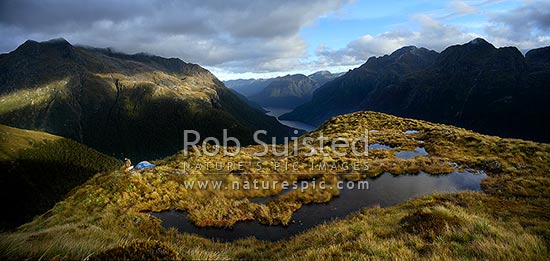
Fiordland Wilderness Travel, Glaisnock tops
The plan is to find trophy Wapiti bulls (incorrectly called Elk to those from North America ;-)) to photograph during the breeding season. Evan Mardell from Wellington will be the other person in the party. I’ll have a new system with me that you can track the last 7 days of my movement via satellite beacon…..

Find me SPOT...
Live satellite tracking (NOTE: has now been turned off as we’re back, but the full Googlemaps tracklog, photos and story are now HERE) of last 7 days travel with my SPOT personal satellite locator. Every 10 minutes or so we’ll transmit location, but in Fiordland where the valleys are very steep sided and vegetation dense, we’ll not always get a reliable link out to the satellite network – but you’ll see, esp. after we climb up onto the alpine tops. In Google Maps/Earth the resolution is so good now over most of this area you’ll get a great satellite image view if you come along for the ride.
Here’s the put in point. We’re flying in by helicopter, walking and hunting around for two weeks and being collected by boat from the Glaisnock River mouth on Lake Te Anau. Zoom into get a better view.
What you should know about this part of the world is that it’s a formal legal Wilderness Area – The Glaisnock Wilderness Area as part of the Wahipounamu World Heritage Area, and Fiordland National Park. This means no tracks, no huts, no bridges, no food drops…nothing but untracked wilderness. Helicopters are not allowed to land except at the high tide mark on the fringe of the area (and in this special case slightly inland at Lake Alice as the coast is ttally inaccessible).
The country is tough – it’s glacial U-shaped topographywhich means that the valley walls are generall very steep or vertical, and the rainfall is amongst the highest in the world. Basically if the ground is flat it’s a swamp, which makes tenting very interesting sometimes. The plan is to spend a few days on the Edith-George tops before finding a route around the catchment to Edith Saddle and then walk out through the Glaisnock River, visiting the famous Glaisnock Rock Bivvy, inscribed with some famous names of old, to be collected by boat on Lake Te Anau.
Apart from the satellite transmitter beacon, our only contact with the outside world will be a small HF radio pack. No cell coverage here! And that’s why most of the gear we’ll be wearing is Swazi Apparel - the best in the world. Looking forward to being back in Fiordland.
So, why Wapiti? Well they arrived in New Zealand in 1905, as a gift from USA President Teddy Roosevelt (go figure), and were liberated into Fiordland. The herd is apparently the only wild one in the southern hemisphere, and this trip would have to be one of the hardest photographic challenges you could undertake – carrying 2 weeks of provisions and gear through tough remote country with an 8 metre annual rainfall (yep, that’s 300+ inches), while trying to get in close enough to wild animals in their environment. Wish us luck, and leave a comment for us to read when we’re back.
Thankfully Janette (Nature’s Pic Images, Business Manager) will be in the office capably handling things while I’m off….. Regards, Rob


they make swazi in pink???
Morena and Kia Orana Rob,
Thank YOU for the invitation to follow ‘in your footsteps’ for a couple of weeks!!!
Good luck with the weather and the calling techniques needed to attract the big beasts…..
Kia Kaha,
Meitaki Maata,
Tihau
Ahhh Rob. Fiordland is the steel hunters use to sharpen their lives. And Mr McCallum, yes we do have pink, but I believe you may be more of a chartreuse man myself.
Good to see you’ve just landed in a legal spot (assuming at this stage your SPOT is actually on your person).
We’ll know if you sleep in too long in the mornings…
Without his expresso coffee from his fancy new coffee machine, the early starts may be a bit harder than usual. Hope he packed the instant!!
aaagh that first foidland cup of tea you have been thinking of, is that 1 or is it 2 sandflies you have with your tea old boy what
I’m still trying to get my head around this new technology and the dilemmas it presents…for example: If we spot you are in fact off your permited huning block is it our obligation as good citizens to make a citizen’s arrest and report you immediately to DoC to bring you in?
What if we see the signal hasn’t moved for days -do we summon Search & Rescue thinking you’ve fallen down the hill or maybe assume you just got clumsy and dropped the transmitter? Or maybe you are just holed up enjoying yourself and don’t want to be interupted?
You should have issued clearer guideance to save us from our uncertainty….
Happy tramping Rob. My longest trip was 6 days…can’t imagine 2 weeks. Enjoy and good luck!
Ah yes, technology is tricky. Rest assurred that Rob also carries an emergency beacon, and has taken an able companion with him:)
Will be watching….Just keep your distance from those flirtatious elk cows. I know how they’re apt to take a shine to you, and we wouldn’t want any bulls chasing you off the trail out of jealousy!
This is fantastic Rob its like we are there with you without the sandflies im sure those that love foirdland will get a real buzz from this, im loving it
We’re really glad your enjoying this Allan. I am looking forward to Rob getting back and seeing some of the photos of the where he was. Makes me feel tired just looking at how far they travel each day, sitting in my nice comfortable office.
This is amazing! Thanks for including us on your journey, Rob!
I’m impressed with the distance covered so far, especially given the weight of Rob’s pack. All those training runs up Mt Kaukau obviously helped.
I’m so impressed with this technology – the satellite pictures are amazing. Rob can also send preset messages and we got an all OK yesterday afternoon. It’s wonderful that in such remote rugged wilderness he can still have a connection with us all.
Thanks for the elk shout out – and since ‘wapiti’ is an Iroquois name, I’d say North America owns the patent on both terms. As a representative, I invite you to use whichever name makes you happiest. Looks like you two haven’t moved too much lately, and I hope that the downpour is about finished. Checking the weather report, you’ve had it a bit rough. Now, let’s see some action on this map, Suisted! We’re tracking you in Seattle.
Well, may catch you down there this weekend Rob. Hope some of your snow will have melted by then for my traverse of the neighbouring blocks! I’ll look forward to seeing your photos and hearing the tale of “the big one that got away”. It has been interesting watching your progress amd it’s a pretty useful gadget for the missus to know where a chap is.
Cheers, Rog
You two may have come out of Fiordland a little earlier than the two weeks planned. I’m looking forward to hearing the stories and seeing the photos in an upcoming blog post. Wishing you both well!
[...] Read our recent 2 week Wapiti filming trip post here. [...]
Cheers Rob ,
I hope your on commision.Im going to buy one.
I wish I was. We’ve had good use from it, and given it some great publicity (with more to come). Maybe SPOT would like to subsidise my next years subs…….How about it SPOT?
[...] up of our 2009 Fiordland Expedition posted originally titled as “Where’s Wally? Live satellite tracking of Rob’s remote Fiordland expedition for 2009” [...]
This was a great read though! Thanks..