Write up of our 2009 Fiordland Expedition posted originally titled as “Where’s Wally? Live satellite tracking of Rob’s remote Fiordland expedition for 2009” post.
The trip was fantastic. Lost about 5kgs/12lbs from sweat and toil…would have been more if the weather hadn’t done its best to muck us up. So, what was the trip all about? Once a year a ballot is run to allow folks to chase Wapiti deer in a remote part of Fiordland. We happened to get lucky in the very popular ballot, so set off into this seldom visited part of New Zealand, seeking in the least to get some great photos.

A unique part of the trip was that I carried a new SPOT personal satellite tracker unit that allowed people to follow us in real time on google earth, as well as an emergency backup with our mountain radio set.  We had quite a following after our original post. So, here’s the write up about the trip…..
Below you’ll find the final annotated GOOGLEMAP of our trip you can play with, filled with our satellite transmissions and photos of the locations. Waypoints are numbered so you can figure which way we went (#1-266). Click on the camera icon’s for photos and further info. Zoom the map below in to see everything and more photos (use ‘+’ or ‘-‘ on top left), and drag map around with your cursor…..
Click to View Fiordland Wapiti exped 2009 in a larger map. *Recommended
> > > Continue reading : full post + comments > > >
QUICKIE UPDATE: 14 April 2009: Well, after some very bad weather (5 days straight stuck in the tent with hail, early snows, storm force winds and thunder/lightning – and no book!) we had to pull the pin on heading over Edith Saddle to Lake Te Anau. Instead, choosing to make our way back to the put in point and fly out 2 days early. Top trip though and we saw some pretty tough country and got some great shots and experiences. 14 days worth of food and equipment meant 31+kg (70 pounds) packs on backs pushing through untracked country – loosing a bit of girth and finding a muscles I’d forgotten about in the process. The live tracking tracks are disappearing now (last 7 days display only), so I’ll post some shots and the full trail in a few days time when I get better sorted. Love the comments you all left – many thanks. Regards, Rob.
NOTE: You can now read the trip write up in this new post
Remote wilderness Fiordland. I’m taking camera and equipment for two weeks unsupported tramping and hunting through some of Fiordland’s toughest terrain, some of the wettest and most rugged land about, and you’ll be able to track the expedition in real time.

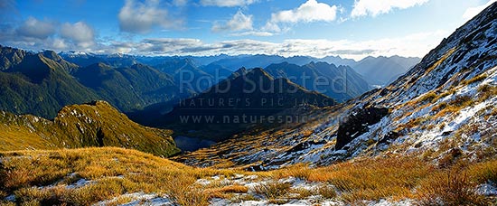
Fiordland Wilderness Travel, Glaisnock tops
The plan is to find trophy Wapiti bulls (incorrectly called Elk to those from North America ;-)) to photograph during the breeding season. Evan Mardell from Wellington will be the other person in the party. I’ll have a new system with me that you can track the last 7 days of my movement via satellite beacon….. > > > Continue reading : full post + comments > > >

 We had quite a following after our original post. So, here’s the write up about the trip…..


